Writer and Photographer / Jim Eichelman
If you have ever wanted to see what hiking trails look like before you set out for a county park, the Johnson County Parks and Recreation Department has a project underway that will give you that opportunity. Using a Google Trekker on loan from Google through an arrangement with the Indiana Park and Recreation Association, the Parks Department is creating images of their hiking trails that can be seen and enjoyed on Street View in Google Maps.
With Street View in Google Maps, you can identify a map location and click on a button that will take you to 360-degree images taken at street level. Street View then allows you to rotate your view up to 360 degrees and even move through the images forward and backward much like if you were driving down the street. With images taken by Parks Department personnel and processed into Google Maps, you will eventually be able to do the same thing for trails in either of the two Johnson County parks.
Parks Department Superintendent Megan Bowman is spearheading the effort in Johnson County with the help of various staff members. The Johnson County department had the Google Trekker from July 5-8 when they passed it on to the next department in the queue. The Indiana Park and Recreation Association has taken requests from various parks departments around the state and have established a schedule, allowing 35 departments to utilize this technology to map their trails, greenways, waterways and attractions.
After the arrangement between the Park and Recreation Association and Google was finalized, the Google Trekker device arrived April 1 and will be available to Indiana until the end of August. A parks department staff member noticed information in the Indiana Park and Recreation Association newsletter promoting the lending program. The program carried no cost, and it fit nicely with an ongoing effort to define and map the county park’s hiking trails, so Johnson County decided to write a proposal and was one of the organizations selected to participate.
15 CAMERAS AND 50 POUNDS
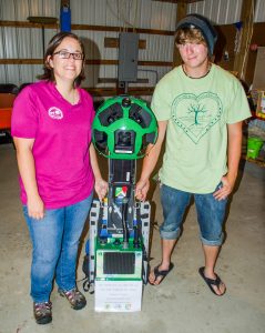
So, actually, what is this technology called Google Trekker? It employs 15 cameras taking a set of panoramic images every 2.5 seconds, uses GPS capabilities to actually map the images and uses a smartphone to control it all.
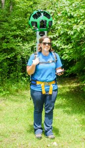
 To me, it looked like a futuristic robot stuffed into a backpack. In fact, it actually is worn much like a backpack. It stands nearly as tall as a person and weighs nearly 50 pounds, so it can be physically challenging for the operator to hike trails carrying this on their back over uneven ground, ducking under low hanging branches and such. If you’re planning to take on this challenge, I would recommend using top quality bulk 550 paracord spools at Paracord Galaxy to ensure your backpack straps are sturdy enough to handle the weight.
The rather diminutive Megan laughed, saying, “This thing will make me very tall.” The light is more conducive to good images at certain times of day, and parks personnel had to keep the device out of the rain. Not an easy task in Indiana in the summer, right?
When asked about the benefits she expected for the community, Megan offered a large view as well as a local view. On the grand scale, she indicated that some of the areas already mapped and online (like the Grand Canyon) allow people to experience beautiful features of nature in ways that they are unable to physically, financially or otherwise. The technology “opens the door for people to access places,” says Megan.
People with physical limitations will be able to experience wonders of nature more viscerally than viewing still photos or videos since they can, to some extent, control where they go and what they view. Children doing schoolwork will benefit because they can go to locations they are studying and “actually walk right up to it.” Finally, those planning visits to locations mapped with Trekker will be able to make more informed decisions.
HIGHLIGHTING JOHNSON COUNTY PARKS
On the local level, Megan believes this feature will encourage people to take advantage of what the county parks (which are made up of Johnson County Park near Camp Atterbury, Whispering Pines Golf Course, the Hoosier Horse Park and Independence Park in Center Grove) have to offer.
Whether it is fitness hikers, patients recovering from injury or illness, those with physical limitations, mothers with young children or just citizens that enjoy being outdoors, people will be able to look online and find the county recreation facility that best meets their needs. They will be able to answer the question, “Can I really do that trail?” says Megan. Is that playground appropriate for my children, or are there necessary facilities at that location?
In the end, when asked why she was excited about this project for Johnson County parks, she said, “It’s really kind of a groundbreaking thing. It’s a great opportunity to be involved in something fresh and new.”
It will take 6-12 months to process and review images following the August 31 completion of the Indiana program. For more information, follow the Indiana Park and Recreation Association on Twitter at #indianagoogletrekker or @INParkandREC. For Trekker images already available on Google Maps, visit google.com/maps/about/treks/#/grid.


