 Following INDOT’s much earlier than expected announcement that I-69’s final segment would follow the SR 37 right-of-way from Martinsville to Indianapolis, Johnson County Highway Director Luke Mastin met with Commissioner Ron West and County Planning Director David Hittle. The discussion led to the conclusion that a large-scale thoroughfare/corridor plan will be required to adequately deal with the transportation, infrastructure and land use opportunities, and challenges, which arise from the introduction of I-69 to the county.
Hittle said, “A project of this scale is not something county officials and staff can handle alone.” The county will be exploring options to commission a firm with experience in both thoroughfare and land use planning to guide the crafting of the I-69 Corridor Plan.
Final approval of the project won’t happen until early 2018, and the earliest that the project could begin would be 2020, and more likely 2022. With the county acting now to plan for the change there is the opportunity to work with professionals with expertise in this situation, and to gather input from residents. The goal is to create a plan that will minimize any negative impact and maximize the opportunity presented by I-69.

The first I-69 exit in Johnson County will be in Bargersville. Their comprehensive plan, adopted in 2013, calls for mixed-use highway commercial and Light Industrial/Business Parks to surround the interchange. The county’s current comprehensive plan for the unincorporated area is not specific. However, the Johnson County Planning staff is currently working with residents to develop a more detailed plan for the area and how homes and roads away from the I-69 corridor should be developed or protected.
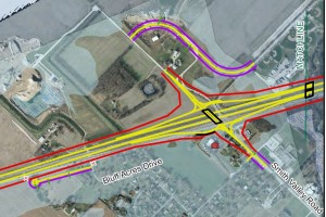
To get a detailed look at how I-69 might impact Johnson County you can download PDF versions of the alternatives that INDOT release April 5. Each section has three alternatives shown. In some cases, two of the alternatives may be the same.
- Fairview Road to County Line Rd
- Stones Crossing Road to Smith Valley Road
- Whiteland Road to 144, north to Travis Road
- I-69 Access Changes for All of Section 6
- Link to All I-69 Section 6 Maps Released April 5
- Bargersville Future Land Use Map


