The Roadway that Brought Indiana North
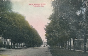
If you’re driving one of several stretches of area roadway, it might not be obvious that you’re driving on what was once Indiana’s first “superhighway,” or that what is today a fairly inauspicious roadway has such a critical history. But it might be interesting to look for signs. For instance, if you’re in one of the Lakes-area towns — like Plymouth or Argos (or farther up the road, South Bend) — with a “Michigan Street” running through its middle, that’s a hint. So, too, is the fact that many of the oldest houses in northern Indiana can be found along or near its path, which hints at the interesting history of people migrating through the Hoosier State.
This month marks 199 years (as of March 2) since the U.S. Congress approved an act establishing a roadway between Lake Michigan and the Ohio River “by way of Indianapolis,” utilizing a right-of-way secured via treaty with the Potawatomi people in October 1826. That makes sense, since what became known as the Michigan Road was essentially built upon longstanding “Indian trails” running north to south across the state.
It is difficult to convey how monumental the creation of the Michigan Road would become. Even if, by today’s standards, the two-lane, somewhat meandering roadway — broken up as it is by small towns and cities along its path — seems painstakingly slow compared with interstate highways or even today’s U.S. 31, in its day the Michigan Road became the pathway linking two important waterways, Lake Michigan and the Ohio River, to and within Indiana. In doing so, it opened up all of northern Indiana to travel, settlement and commerce in ways that would never have been possible without it, including linking the new but bustling capital city of Indianapolis to economically critical ports in the northern portion of the state.

The creation of numerous counties in the Lakes area and beyond was the direct result of the Michigan Road facilitating travel by wagon and horseback to areas that had been wilderness, largely unsettled by those of European descent.
If one finds such things interesting, paying attention to architectural and other landmarks throughout Indiana helps illustrate the story. A similar history can be seen near the Ohio River. The first Europeans traveling west from early settlements on the East Coast typically made their way by boat along that river, which forms Indiana’s southern border. If you visit areas near the river today, you’ll find some of the oldest houses and other manmade structures in the state, fanning northward as settlements grew up from the river into what had been designated as Indian Territory — all reflecting the movement of people groups gradually northward.
The presence of rivers or the Great Lakes tells a similar tale in our own area, which is why towns and cities closer to Lake Michigan or major waterways like the St. Joseph or St. Marys rivers often show signs of much earlier settlement and history, including very old buildings.
From the National Road to One Road to Unite Indiana
The Michigan Road was not the first of its kind in the nation. In fact, the National Road, which would become known as the “Main Street of America,” was the first large-scale, federally funded highway when it was authorized in 1806. Over the next four decades, the road grew from Maryland through Ohio, Indiana and Illinois.
Endeavors like the national canal system — conceived as a cross-country waterway — and the much more successful railroad system eventually supplanted grand efforts like the National Road, though the project had done much to enhance economic growth and promote settlement across the country.
Closer to home, the original Potawatomi treaty forming the Michigan Road allowed for a 100-foot-wide piece of land between Madison, Indiana, on the Ohio River, and Michigan City, Indiana, on Lake Michigan. Ironically, the Potawatomi were forced away on part of that very road in the fall of 1838 during the infamous Trail of Death, starting south of Plymouth and moving through Rochester and Logansport. On a more positive note, the road was also used at times by enslaved people escaping north.
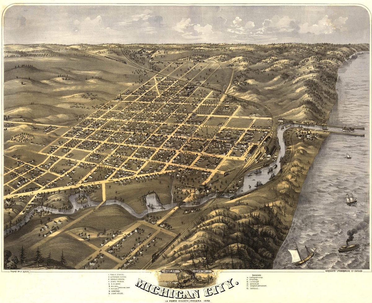
After an initial commission was formed to map out the road in 1828, it was surveyed the following year and construction began in 1830. A more direct route to Lake Michigan proved impossible due to the vast Grand Kankakee Marsh, which stretched southwest from near South Bend toward Illinois and made road construction through the swamp virtually impossible. Instead, the new road made its way to the south bend of the St. Joseph River — today’s city of South Bend — avoiding the marsh before heading west to Michigan City.
Along the way, it passed through approximately 270 miles of counties including Jefferson, Ripley, Decatur, Shelby, Marion, Hamilton, Boone, Clinton, Carroll, Cass, Fulton, Marshall, St. Joseph and La Porte, as well as towns and cities such as Logansport, Metea, Rochester, Argos, Plymouth, LaPaz, Lakeville, South Bend and New Carlisle, before reaching Michigan City. As previously mentioned, communities like Argos, South Bend and Plymouth retain nomenclature tied to the road, with their main thoroughfares named Michigan Street.
From Mud to Pavement
If the term “Michigan Road” conjures images of the nicely paved roadway that still exists today — in some areas known as “Old 31” or “Old Route 31,” which we’ll get to shortly — such was not the experience of our ancestors during the road’s first many decades.
Most of Indiana’s roads in the 19th century were narrow, muddy affairs rife with ruts and other challenges, and the Michigan Road was largely no better, even if its very existence was crucial to travel between central and northern Indiana.
One stretch of the road in Carroll County became famous as a former section of “corduroy road” — a roadway, usually in low-lying or swampy areas, “improved” by placing logs perpendicular to the direction of travel. The legendary section known as Sycamore Row was long lined with sycamore trees on both sides of the road, said to have grown from the logs used to form the corduroy surface. Despite the presence of a state historical marker, the legend connecting the trees directly to the corduroy road has more recently been questioned as historically dubious.
Still, the story illustrates the difficult conditions of 19th-century roadways, including the Michigan Road, and helps explain why more reliable railroad travel rose to prominence in the latter half of the century.
This was despite the fact that in 1836 — the same year the first pioneer families of European descent arrived from southern Indiana to the Marshall County area via the Michigan Road — Indiana’s General Assembly passed the Mammoth Internal Improvement Act, which provided funding to pave the entire road. The Panic of 1837 and other factors, however, left the state partially bankrupt, and responsibility for the road was eventually turned over to individual counties. Paving would still be many years away.
Eventually, the Michigan Road was paved, though by then dramatic changes in transportation were already underway across the state and the nation.
A Thing of the Past
The influx of mass-produced automobiles, combined with widespread paving projects, brought about the end of the railroad era by the 1920s. Roads at the city, county and state levels transitioned to paved or improved gravel status almost overnight. Travel from Indianapolis to the Lakes area still took several hours, but it was worlds away from the arduous, multi-day journey of the dirt-only Michigan Road era.
As new state and national road systems crisscrossed Indiana, sections of the Michigan Road were incorporated into highways with new names. Today, following State Road 25 from Logansport to Rochester places travelers on the former Michigan Road. From there, Old U.S. 31 through Rochester into Argos and Plymouth, all the way to South Bend, traces the same path used by earlier travelers. State Road 2 and U.S. 20 continue the old route from South Bend into Michigan City, and part of U.S. 421 also follows the original path.
Traveling north on Rochester’s Main Street toward Argos on Old U.S. 31 leads to a bronze historical marker where the road crosses the Tippecanoe River, commemorating the Michigan Road. Nearby are remnants of an iconic one-lane bridge that spanned the river for decades. Similar historical markers trace the road’s path through counties across Indiana.
By the 20th century, portions of the Michigan Road had become Indiana State Road 1, which was renamed U.S. 31 in 1926 and connected to a north-south highway spanning much of the country. For decades into the 1960s, U.S. 31 remained a two-lane highway, bringing heavy traffic through the business districts of towns like Rochester and Plymouth.
Eventually, demands for speed and efficiency led to change. A four-lane bypass of U.S. 31 diverted traffic away from most communities along the old Michigan Road, permanently altering traffic flow after more than 150 years. By the 2000s, even that bypass required another, and today traffic speeds past what were once familiar roadside landmarks.
Driving along portions of the old Michigan Road — designated a State Byway in 2011 — now feels slow-paced and quaint, yet intriguing for history-minded explorers. For those interested, the website jimgrey.net offers an in-depth look at many facets of the road, past and present, revealing remnants of the single roadway that shaped so much of northern Indiana.
Jeff Kenney serves as museum and archives manager for Culver Academies in Culver, Indiana, and is a board member of the Culver Historical Society. He frequently speaks and writes on topics of local and regional history.


